
39. Burnaby to Victoria

Entering Vancouver Harbour
June 14 to June July 3, 2019.
Our plan for this trip was to follow the tanker trail: from the Trans Mountain Pipeline Terminal in Burnaby, B.C. to the Strait of Juan de Fuca where the big ships head out to open ocean. There has been huge controversy about tripling the capacity of the pipeline that carries diluted bitumen (dilbit) from the Edmonton area to Burnaby. For starters, Canada has international commitments to reduce its emissions by over 523 megatonnes a year by 2030 and projections show that it is currently on track to exceed that by over 200 megatonnes. The economic outlook for the expansion doesn’t look so good either. The International Energy Agency predicts that oil consumption will peak as early as 2020 and the price will fall after that to approximately $30 per barrel as progressive countries switch their economies to renewables and economies falter. The marginal costs of the oil sands are estimated at over $60 per barrel. Where’s the benefit in that? There is considerable concern about the demand for bitumen even at today’s prices. According to a well-researched article by Briony Penn, writing in Victoria’s Focus magazine, only 20 tankers carrying bitumen have left for China since 2014. The terminal in Burnaby has been severely underutilized and almost all the bitumen that did get shipped went to California refineries. There is not much demand for bitumen in Asia. It’s expensive and difficult to refine. It is important to consider what officials who have a global, rather than local, understanding of the future of energy have to say. Here is OECD Secretary General Angel Gurria’s recent comment: “Our policies have to be made with our children’s future in mind…short-term decision-making can lock countries into expensive mistakes in financing and developing infrastructure…that will be neither necessary nor profitable in a low-emissions world, they will be stranded assets.” (Jonathan Watts, Guardian, July 5, 2019) There is also the matter of 1 trillion litres of polluted fluid fine tailings (FFT) being contained in tailings ponds covering 220 square kilometers. These are already leaking into the Athabasca River and the companies involved want to start releasing them on a regular basis. All remediation efforts have failed. Liabilities of the oil and gas sector have been estimated as high as $260 billion. If an industry can’t properly dispose of its massive quantities of waste, and doesn’t know how, can it be considered successful?
As mentioned earlier, the challenges and risks of containing and recovering dilbit in the event of a spill at sea have not been studied sufficiently and recovery exceeding 10% in rough conditions is remote. The risks have been underestimated by the industry.
Our passage will take me down memory lane, where I worked and commuted by kayak for years, and past the most biologically productive environment in all of Canada. As in all large urban areas, there is increasing pressure from industry and developers on the natural surroundings.
Kit was on hand with Theresa to see us off. We had stayed the night at his and his wife, Jill’s home in nearby Deep Cove. We go all the way back to kindergarten. It was with him that I cycled, along with two others, across the country to PEI. To paraphrase Leonard Cohen: “Just 4 young guys in their mid-sixties with a dream”. Kit is a geophysicist by training and has a wry wit. He says that he has spent most of his working life chasing after “useless rocks” (diamonds). I think that he has been pretty successful at it. He had come down to our departure point at Cates Park, across Burrard Inlet from the Trans Mountain Terminal, on his titanium road bike. He was training for a multi-month cycle trip in Africa. If the subject turns to the climate crisis he says with a grin: “We’rerrr fucked”.
We paddled across to the marine loading terminal on the south side of the inlet. There is a boom across its entrance that was expanded after protests by kayakers and canoeists led by First Nations. I had been there once towing a huge, black inflated tube with red Xs on it, meant to indicate no to a pipeline. It had seemed like a good idea at the time, but it was windy, and the giant sausage kept pushing me off course, like a huge, out-of-control tail wagging a lap dog.
On the north shore, across from the terminal, sandwiched between Cates Park and chemical storage vats farther west, is the home of the Tsleil-Waututh Nation. Of all the communities affected by the terminal and tankers they are probably the most at risk and have been amongst the leaders in the protest against the expansion of Trans Mountain. There is a gravel bank extending offshore that drains at low tide, which probably has clams and fin fish, but I doubt they harvest them. Fecal and hazardous chemical levels are high in the area. They have lost much already.
We paddled under the Second Narrows Bridge, (also called the Iron Workers Bridge) aided by a strong ebbing current. In 1958, during construction, several spans collapsed, causing seventy-nine workers to plunge into the water, leading to 19 deaths, some attributed to the weight of their tool belts. I still have a dim memory of that.
Entering Vancouver Harbour
My sister and her boyfriend once owned a home in Deep Cove. I paddled to her place through the port from Kitsilano, where I rented a room, a few times. I would stay the night, have a visit, a free meal, and then return with the tide the next morning. But, that was decades ago and things were looser back then. This time we decided to keep a low profile, stay close to the docks on the north shore and try to blend in as much as two guys in expedition kayaks, wearing bright yellow PFDs, can do. We were just approaching what appeared to be a new grain loading facility when a large power boat came towards us at full speed, with blue lights flashing. When it got closer we could see that it said “Port Authority” in large letters. “Do you have any idea why I just drove this boat fast up to you guys with lights on?” asked the grey bearded captain of the Takaya. “Um, maybe because we’re not supposed to be here?” I asked. “You’ve got that right”, he responded. “I’m going to have to load you on this here boat and take you out of here.” The boat had a low transom and it was easy to haul our kayaks onboard. He then asked where we had launched and if we had a car there. I told him that we had been dropped off at Cates. He asked us where we were going and I told him Victoria, but today just to either Kitsilano or Marpole. Then I suggested that instead of taking us back to where we started he could just offload us somewhere past the Lions Gate Bridge, off Stanley Park, and out of his concern. He was stern with us, but friendly, and he agreed. We got set off just shy of Siwash Rock. During that brief passage his mate asked about kayaking, where to go, is it safe, that sort of thing. I showed him the VHF radio that is always attached to my PFD, my flares, and we talked about other safety concerns. He had been in the merchant marine for 12 years and was an experienced seaman. He also explained that the rules for entering the port had been tightened recently. No paddle boards, sailing, kiting, paddling; nothing without a motor.
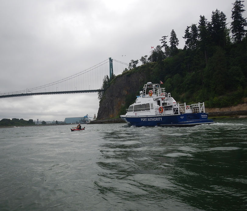
Port Authority carried us through the harbour.
When we entered False Creek under the Granville Street Bridge, we noticed a large new painting called The Birds of False Creek. It showed the birds that I saw during the 26 years that I paddled three or four times a week from my home in Kitsilano to our shop on Granville Island. Most the birds that I would encounter, including geese, grebes, duffel heads, golden eyes, cormorants, crows, mew gulls, glaucous gulls, and eagles were there. They were well painted on a modern pink background. Some things get better.
And some things don’t. We rounded the small marina into Alder Bay, where I used to pull out. The marina there has boats worth hundreds of thousands (or millions?) tied up to cheap wharfs floated on Styrofoam blocks. Over time the Styrofoam has deteriorated, and pieces regularly break off and float away. (Newer wharfs usually have concrete or solid plastic floats). I wonder if there are regulations about that.
Evan and I made our way to our old shop building and looked inside. It’s been over two years now and the place is still empty. The wheels of the Federal Government turn slowly.
In 2001 a group called “Friends of False Creek” began a program of testing the water quality in False Creek. They needed a couple of kayakers to take water samples throughout the creek. My colleague, Kevin, and I volunteered. This was easy for me because I was paddling to work anyway, but Kevin had to arrive at the shop early and get into his kayak there. Every Wednesday morning, before work, for a year and a half we took water samples in sterilized plastic bottles at several designated positions in False Creek. At each site we took one sample for testing for fecal coliform and another for enterococci. After collecting the samples, we went ashore with all of our bottles and put them in a cooler which was picked up by a team member and taken to two testing facilities. The program was supported initially by the GVRD (Greater Vancouver Regional District), and by scientists from the provincial and federal governments. It was already known that there were pollution problems in False Creek, but we wanted to more accurately learn about the scale of the problem and identify sources and the effects of weather, if any. At the time there were dozens of small boats moored in the creek, some with people living full time on them. We thought that this could be a source of pollutants. Bigger concerns were the three CSOs (combined sewer overflows) that drain into the creek. The system is designed to send sewage directly to a treatment plant. However, during rain events this can be overwhelmed and the excess spills into the CSOs and flows, thanks to gravity, into the creek. With increasing population densities comes increasing sewage and increasing stress on the CSOs. The GVRD already knew about this and had a 50-year plan to increase the capacity of the sewage system. This seemed a little far off to me. Although the GVRD seemed like a reluctant ally, the provincial and federal scientists were great. The federal guy, whose specialty was shellfish, told us that one day he hoped to eat oysters from False Creek. However, he wondered if the report would ever see the light of day.
Recommended limits for body-contact for enterococci are 35 colonies/100 mL sample. Limits for body-contact recreation for fecal coliform are fewer than 200 /100 mL and for fishing and boating: fewer than 1000 /100 mL. Kayaking would seem to have more exposure than ordinary “fishing and boating”. Safe limits tend to be seen as 200 colonies/100mL. During the months that we were collecting samples we heard about “very high readings” and “readings off the chart” of both pathogens. It was found that the highest readings occurred after a dry period that was followed by substantial rain, which flushed the CSOs out. The presence of the small boats was found to not be a significant factor. Highest readings were near the outflows. One email indicated fecal coliform results ranging from 45,000 to low 1000’s. At that time there was massive development of apartment towers and townhouses, especially on the north side of the creek. Land prices sky-rocketed (which contributed to our shutting down boat manufacturing.) Both the city and the developers made a lot of money. After we finished the program, we waited for the study to be completed and publicized. We never did see any results. There must be a report somewhere about pollution in False Creek sitting on some dusty digital shelf. Meanwhile there is a large population living in luxury apartments on some of the most valuable land in North America surrounding the “urban jewel” that is False Creek that sometimes more resembles a cesspool. If you want to see the “natural jewel” of Greater Vancouver you need to look just a bit further south.
We used to sell our kayaks to a chain of large outdoor stores headquartered in Hamburg, Germany. Many people don’t realize that Hamburg has more kilometers of canals than Venice. The Alster River is especially interesting because on its journey through two small lakes to the Elbe River it flows through some beautiful old estates that are only visible from the water. Like Vancouver, Hamburg has a history of overflowing CSOs that polluted the water to the extent that people were warned off the Alster, and massive fish die-offs occurred. Unlike Vancouver, Hamburg decided to do something about it. A few years ago, I was paddling there with a German acquaintance when we came to what seemed to me to be a large handsome dock. “What’s this for?” I asked. It was explained to me that it was one of several huge underground storage basins for holding water and sewage after a rain event when the CSOs could not handle the excess. Once the rain passes the sewage can be pumped back to the treatment plant. Today you can swim in the Alster and be confident that the authorities monitor the situation closely. The Alster and its two inner-city lakes are now known as “the internationally admired wet bits that make Hamburg what it is!” (How Hamburg became European Green Capital…) Could this system work in False Creek? I’m no hydrology engineer, but intuitively, you would think so. Vancouver gets more rain (1167 mm/yr. average vs. 768 mm for Hamburg), but False Creek is much smaller. There are only three CSOs. There are federal guidelines on pollution limits for marine waters and there is no way that False Creek meets those. All the various governments concerned have been turning a blind eye to the problem for decades. You would think that there would be funding available from the federal government and also from the developers that have made their millions from building the place out. It may just be a matter of not caring enough. One thing that our little study may have influenced: some time after the project was wound down signs went up at various parts of the creek warning about pollution levels after rain events. (Note: on July 27/19 during a weekend for fireworks, nearby Kitsilano Beach was closed for swimming. One sample for E. coli came in at 12,997 per 100 ml. Safe is 200.)
On our way out of False Creek we passed Fisherman’s Wharf. It was here in 2012 that members of the Squamish Streamkeepers Society began wrapping protective plastic around creosote-treated pilings. Herring like to lay their eggs on the pilings, but the creosote kills them. There hadn’t been any herring in the creek for many years. The Streamkeepers had started wrapping pilings in Squamish a few years earlier. Six years later a strong herring run had attracted hundreds of dolphins and Orcas. The group also installed hanging nets in False Creek where herring can lay additional eggs. In 2018 a billion eggs were laid. This is such a phenomenal result the streamkeepers predict the return of dolphins and orcas. What a terrific success for a volunteer group with a vision and determination to carry it out.
We paddled out of False Creek, past Vanier Park and Kits beach. Further along is what I have long called the “sewer lot” This is another large CSO that has a bad smell during rain events. For a number of years, I lived a few blocks inland from there and launched from the pipe that extends out to sea. (Later I moved farther west, and my launch site was below a steep staircase.) Beside the CSO is the most valuable home and property in B.C. I call it “Chip’s Big Bunker” because it is constructed from massive concrete slabs. When Chip first built it he had a mural painted on the substantial seawall that fronts his property. It was attractive and featured some cartoon characters and a beautifully painted bird. Unfortunately, he did not get city approval and they made him paint over it. For years after that there were only ugly tags and markings on the wall. I saw that this time, though, the wall had been painted bright baby blue. It is visible from far and wide because it is the biggest and brightest. It doesn’t look as fine as the original, though. Chip’s claim to fame is that he was able to convince half the women in the First World to wear tights on the street. They must be comfortable.
As we rounded Spanish Banks and Point Grey at low tide, far out past shore, we passed by a few Herons, standing in ankle deep water, fishing. Always a good sign. When we entered the North Arm of the Fraser River on an incoming tide the vast array of pilings that the logging industry uses to hold fast their log booms came into view. What surprised me was that most of them were empty. In years past there would have been booms tied up to most of them. Now there were logs only directly along the navigable sides of the river and a couple of small tugs pushing them around. I wonder if this is another indication of the decline of B.C.’s forest industry?
I had been looking forward to paddling the Fraser River Estuary, an area I don’t know well. It has long been the greatest salmon river in the world and is a feeding place for hundreds of thousands of birds. But the approximately 2 1/2 million human inhabitants of greater Vancouver are pushing against its natural fecundity in many ways. 70% of its waterways are impacted by dams, levies, causeways, gravel quarries, dredges and other structures. This is part of a worldwide trend. According to Scientific American, August, 2019: “Only 23% of the subset of the longest rivers that connect to the ocean are unimpeded along their entire lengths…for the rest human infrastructure is starving estuaries and deltas of key nutrients”.
A little farther up the North Arm we came upon the Iona Sewage Treatment Plant that treats sewage from Vancouver and Richmond. Sometimes the smell is pretty bad but, on this day, with a favorable breeze, it was O.K. This is a primary treatment plant only, which means that only solids are removed. It does not remove toxic chemicals dumped by households, businesses, and industry, including heavy metals such as mercury, lead, copper and chromium. The waste effluent reduces oxygen in the water, which suffocates fish. There is a plan to build a new plant with secondary waste capabilities by 2030. This would treat the water at a microbiological level, but still will not remove toxic chemicals. Quite a few environmentalists are pushing for tertiary treatment.
Urban paddling presents special challenges. You can’t just go ashore, dig a hole, have a poop, and set up camp. (Even though in this case the waste treatment plant was just downstream) For this special trip along Vancouver’s environs, my wife, Theresa, picked us up and dropped us off in our small electric car. Payback will come later. We pulled into Milltown Marina at the foot of Granville Street. This has the feel of a family operation. There is a sizable dock area, a pub with good food, a storage area for boats and lots of good energy. I think that they lease the property from Squamish First Nation. They tolerate us even though we don’t belong to the marina. We do eat their food and drink their beer, though. One day I carried my folded kayak on the Skytrain to New Westminster, launched not far from the market on the quay there and headed down river with the tide. When I pulled out at Milltown and started disassembling my kayak, I happened to meet the manager. It was winter. He asked me what I was doing, and I told him where I had launched and that I was walking to the nearest car2go rental to drive home. He told me to hop into his car and drove me to my rental. When I first led Evan on a similar route, I didn’t tell him about the pub beforehand and you can’t really see it from the water. That was a welcome surprise for him.
As we paddled the East Arm of the Fraser alongside Sea Island the next day, we passed a lot of power boats tied up at marinas. I’ve wondered in the past about what level of emissions they create. Boats are inefficient because water is difficult to push through. This is obvious to a paddler. Battery powered boats do exist, but so far lack range and speed. Most of these boats, which are often seen as pits to pour money into, are not used much. Maybe three weeks a year. A report prepared for the GVRD and federal government indicated that the amount of GHGs they spout is substantial, but small compared to other sources. For example, for B.C other than the GVRD and Fraser River District, oceangoing vessels contributed 699,073 tonnes of CO2 in 2000, fishing vessels contributed 14,324 tonnes and recreational vessels: 7,877 tonnes. B.C.s total emissions in 2015 were 63.3 million tonnes. There is a group called “Clean Marine BC” that is promoting environmentally sound recreational boating. They at least recognize some of the issues and are trying to deal with them.
After passing the Olympic Oval and under the two bridges connecting Sea Island to Lulu Island we caught up to some Canada Geese swimming along shore. They seemed to be going as fast as they could, but did not fly. At first you couldn’t see them, as they were sheltered by the adults, but yes, there were a number of goslings in there. We swerved away from the bank to give them some space, but yikes, a seaplane was suddenly bearing down on us. We just stopped then and watched the Harbour Air seaplane land and taxi up to the dock below the Flying Beaver Grill and Bar. Harbour Air is the largest seaplane airline in the world and they have some great news, especially for an ex-pilot like me. They are teaming up with MagniX, a company in Redmond, Washington, that makes electric motors and battery systems for airplanes, to make a completely electric, zero emission airline. Tests on a de Havilland Beaver powered by a 750 HP electric motor will begin this year. (The test flight, flown by company founder Greg McDougall, on Dec. 10, 2019, was successful) The airline serves more than 500,000 passengers on 30,000 short distance flights every year. This is significant. In 2018 75% of worldwide flights were 1,000 miles or less, and that is the market that MagniX sees developing. The electric planes should be much quieter too. Back when I was training to be a commercial pilot some of the bush pilots were quite deaf, which is one reason why I didn’t make a career in aviation. I like quiet. I ended up spending a lot of my time in a noisy machine shop instead.
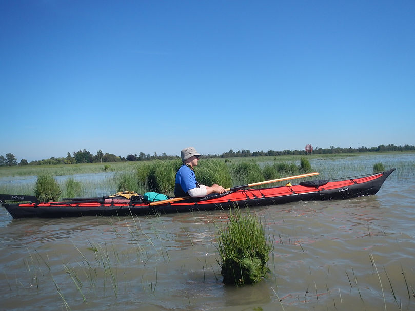
Evan, off Sturgeon Bank
When we paddled up to Swishwash Island at the entrance to Sturgeon Bank we still didn’t know if we would have enough water to paddle much further. I had never been there before and did not know at what tide level we would be able to continue. We could see the Coast Guard hovercraft station just across the channel beside Vancouver International Airport. They could operate at any tide. If an airplane ever crashed onto Sturgeon Bank, just off the runway, those hovercrafts would be the only crafts that would be able to reach them. Our timing was good: it was the beginning of summer, and the huge flocks of migrating birds would not be there. We didn’t want to disturb them. Many years ago, an ornithologist explained to me why he hates kayakers: he often watched them paddle near Stanley Park. They would go in close to shore and send off every bird in sight. This may not matter if it happens once to a few birds, but for flocks to be repetitively displaced while attempting to re-fuel for exhausting flights it is harmful to them. Ever since then I have attempted to stay clear of them. It helps to know a little about the birds. For example, along the south shore of English Bay in winter there are often large flocks of Goldeneyes and Surf Scoters. They often are seen together, but the Goldeneyes generally are closer to shore. They tolerate paddlers a little more than the Scoters, which are extremely skittish and don’t venture into False Creek. Just because you are in a non-motorized craft doesn’t mean you can’t cause harm. Give them a wide birth. Carry binoculars.
As it turned out we had just enough water, and with the tide coming in we paddled out past saltwater marshes with cattail and bulrush sedges, out around the sand flats, through a space in the Steveston Jetty and pulled in at the docks at Steveston, on the south end of Lulu Island in Richmond. Along the way we saw lots of eagles, seals, herons, and gulls. The water, which had come in over miles of sand and marsh, was as warm as in the tropics. It was brown and in some areas was extra thick and had swirls that looked like coffee with creamer that had not completely mixed in yet. This mix of salt and fresh water together with absorbed plant matter from Sturgeon Bank will eventually coalesce into a coating that sticks to the sand and mud. For years I’ve watched Sandpipers up and down our coast scoot along sandy shorelines with their beaks held down low. This seemed like a high-energy activity, and I wondered what they got out of this, what was in it for them? I had no idea. It has only been in the last few years that biologists have discovered that it’s all about the mud. The sticky stuff that covers the sand and mud is called biofilm. It has the consistency of snot. The Fraser Estuary biofilm is some of the most nutritious anywhere and one of the reasons the estuary rivals tropical rainforests in biodiversity and productivity. The Fraser River Estuary extends from Point Grey south, encompassing Sturgeon Bank off Sea Island, Roberts Bank between Steveston and Point Roberts, and Boundary Bay east of Tsawwassen.
It is on the Pacific Flyway, which is the route that birds take along the west coast of the Americas on their migrations from as far as Patagonia to Alaska and the Bering Strait area of Russia. Birds need to stop and refuel along the way and probably the most important stop of all is the Fraser River Estuary. It is recognized internationally as an IBA (Important Bird Area) and is the most important bird conservation area in Canada. As many as 500,000 Western Sandpipers were counted feasting on the biofilm on a single day (pre-2001). Fifty species of shorebirds have been recognized including Dunlins, Black-belled Plovers, Swans, and Wrangel Island Snow Geese. The delta supports up to 1.4 million birds annually. Without the Fraser Estuary the survival of these birds would be in jeopardy. The area includes the Reifel Bird Sanctuary and the Alaksen National Wildlife Area.
Otto Langer is a retired Department of Fisheries and Oceans marine biologist, and local environmental activist. Here is what he says about the importance of the river for salmon:
“Basically this is the bulrushes, the cattails and further out, the carex marshes. Its sedge,” referring to Sturgeon Banks, a strip of marshland and mudflats that run the length of the West Dyke Trail.
“That’s basically the engine that drives the Fraser River Estuary and makes this piece of land all the way from UBC to Point Roberts one of the more productive estuaries in the world. So, every year, the plants convert solar energy into useful carbohydrates and sugars and they’re eaten by the insects and break down. In the spring you have billions of insects in the river, and when the (juvenile) salmon come down the river you might have up to a billion in one year. That’s what they feast on. This is their nursery ground. Without the marshes we are a little bit lost”. (Richmond News, Aug. 1, 2014).
The survival of salmon from the greatest salmon river in the world is dependent on maintaining a healthy estuary.
As we rounded the south point of Steveston Island and pulled into the community of the same name I was reminded of a trip a few years ago. My old pal Shiro Ose was visiting from Japan. He had heard a little about the Japanese connection with the community and wanted to see it. I took him on the Skytrain to New Westminster. From there you can choose which arm of the Fraser you wish to paddle down. This time we took the South Arm, which takes you under the Alex Fraser Bridge, past Ladner, and, if you angle north when you approach Westham Island, dumps you out at Steveston. It was raining and grey, but still interesting to Shiro. As we pulled in, we saw a Japanese flag on one of the fishing boats. Before World War 11 there was an active Japanese fishing community there. They even had their own, highly successful baseball team. When the war started, to Canada’s shame, the Japanese, even those who were Canadian citizens, were treated as enemy aliens and herded up and transported to the interior of B.C. Their land, homes, fishing boats and most of their personal belongings were confiscated. Since then, quite a few have migrated back and started families and there is still a sizable Japanese community in Steveston. Shiro really enjoyed the fish and chips from Pajos.
The history doesn’t start back then, or even in 1877 or 1878 when Manoh Steeves first settled there. About 9,500 years ago Richmond started rising from the silt and sand of the Fraser River. But according to their oral history, north of present-day Sea Island the main Musqueam village was already thriving. It was only after another 6,000 years had passed that present day Lulu Island had become stable enough to enable permanent habitation. Before white settlers came there were at least 2,000 people living in Richmond, and more than 20,000 would come during the salmon runs. Some of the nations from Vancouver Island had fishing rights in the region, as did the local Tsawwassen and Kwantlen families. These were all Coast Salish people. The arrival of white settlers brought disease, especially smallpox. During the 1780s 75% of the population died. The area was described by Captain George Vancouver as “abandoned villages with scattered bones.” (Graeme Wood, Richmond News, June 17, 2016)
When we traversed Sturgeon Banks to Steveston we used the incoming tides to shorten our route. I wanted to do something different for Roberts Bank. My chart indicated that Canoe Passage, which has an entrance off the south end of Westham Island, might be navigable during any tide. We decided to give it a try during low tide, knowing that if we got stranded, we could just wait for it to turn.
When we swung around the south end of Steveston Island the next morning we could feel the current from the outgoing tide and outflow of the river working together. We paddled close to the island and were able to make our way upstream until we were about even with Reifel Island on the other side of the channel. Then we started ferrying across. Soon we realized that the combined current was stronger than we were. We lost ground relative to the island and started slipping out to sea. Eventually we were able to side up to the line of pylons that make up the south side of the jetty. Here the current was a little less strong and we could make some progress. We came to a gap between the pylons and were able to slip to the other side of them. It was surprising that here the current was about half as fast as it was just on the other side, a meter or two away. It was shallow, too, as you would expect. In the slower flowing current sediment would more easily sink to the riverbed. We were able to make our way up to Reifel Island, get out and push our kayaks back through the pylons to the river and continue on our way. At this point we were out of the main channel and although the current was still running strong against us, we made some progress. We paddled alongside Reifel Bird Sanctuary and the adjoining Alaksen National Wildlife Area. On the shore of Westham we passed some very old, tall pylons with tufts of grass or sedge growing on their flat tops. These may have supported a pier owned by Brunswick Cannery Company, which operated from 1893 to 1926. The buildings were demolished in 1983. I thought that once we rounded the east side of Westham Island we might get a boost from the current as we entered Canoe Pass and headed out to sea, but no such luck: the current just died. The only waterfowl we saw was a Trumpeter Swan that seemed to be begging beside a houseboat.

Easing boats through Steveston Jetty
Once we passed the entrance to the passage and left Westham Island behind we entered a vast expanse of low sand and mud bars. I thought that the sedge might have extended out farther. We got out of the kayaks once and quickly sank up to our calves in mud. There were pylons spaced widely apart to mark the passage, but only about 6 for the whole winding, 5-mile route. It was easy to miss a turn. (This is the way the whole estuary used to be: open to the elements and always changing. Today the mighty Fraser has been tamed by dikes, jetties and walls). We might have missed a turn a little later because it became so shallow, we had to get out again and pull our boats behind us. Here the sand was firm. There were sea eagles standing on the low banks. Two were actually in the water. One was rinsing itself in the brown soup, like a robin in a birdbath. I have never seen that before. As we got farther out the sand banks disappeared under the incoming tide. This made navigating the shallows even harder. We headed for a long row of herons, standing like sentinels along the side of the channel, guiding us. Once we got past the sentinels Evan got out of his kayak and started pulling his boat in ankle deep water. It was a strange sight, watching him miles from shore, as he seemed to be walking on water. I kept paddling out to sea until I was over eel grass, which envelops the banks, at the sub-tidal level, providing buffer from the sea and valuable nutrition and fish nurseries in a contiguous arc from Point Grey to Boundary Bay. I continued around the edge of the extended bank and waited for Evan to finish his long walk on the water. We then headed over to the Westshore coal export terminal. As we approached, we could see water or some liquid being sprayed on the coal to keep it from blowing onto the water. This terminal must be hugely profitable for majority owner Jimmy Pattison and his partners. In the U.S., electric power companies are moving en masse away from coal and embracing renewable power and natural gas. This is not due to any tax or incentive by government. Coal has become uneconomic. The coal companies were extremely worried about their future and moved to increase their exports. Unfortunately for them, exporting soft, dirty, lignite coal to be burned for power in Asia has so far proved too controversial for the citizens in Washington and Oregon States. It doesn’t matter where it is burned, coal is a dirty and dangerous fuel that accounts for 43% of total GHGs worldwide, which is more than oil or gas. (World Resources Institute). They found a willing partner, though, in B.C. Unlike in the U.S., marine terminals are a federal responsibility and override local and provincial concerns. Today Westshore Terminals is the largest export terminal of coal in North America and therefore one of the largest contributors of GHGs on the planet.

Westshore Terminals: biggest exporter of coal in North America
There was a strong current running against us as we rounded the coal terminal and headed for our takeout on the ferry causeway. The water, which had been brown, changed to green. The huge causeway that connects Westshore Terminal to the land effectively cut off the sediment from the Fraser. Perhaps an unintended consequence. You can see on Google Maps that the nutritious brown sediments have been carved out of the area between the export terminal and ferry terminal. I wonder what would have happened if the causeways had been made with tresses to allow the water to flow through, rather than on rock piles. Perhaps some planning committee would have complained that the extra cost was “not justified”. The Tsawwassen First Nation land spans the space between the two causeways. The natural wonder of biofilm and all the birds and fish that that engenders has been taken from them. But they got even, sort of. They built a humongous shopping mall on prime agricultural land beside the causeway that goes to the Ferry Terminal.
Sturgeon and Roberts Banks, which looked so stable to me on two fine summer days, are in danger of disappearing. Over the past 20 years scientists tell us that they have been eroding at the alarming rate of 10 to 15 meters per year. This rate will increase with global warming, bigger winter storms and rising seas. The most likely present cause is the dredging done on the Fraser Riverbed to accommodate shipping.[1] Every year the port excavates between 2.5 million and 3 million cubic meters of sediment. That is more than reaches the banks. The material is sold to developers to use in construction. As the industrialization of the Fraser continues there are plans to increase the depth of the river substantially. According to a report from the City of Richmond, in 1960 the draft of the main channel on the Fraser was 8.7 meters. By 1976 it was 10.7 meters and there are plans to increase this to 11.5 meters. Surrey Docks wants the draft increased to 13.2 meters and there are further plans to accommodate vessels with draft up to 18 meters. This will lead to more erosion. Right now, the George Massey Tunnel is an obstacle to the largest increase, but there are plans to remove this and other impediments once a bridge is built to replace the existing tunnel.
The massive sediment removal is the leading cause of the erosion of the banks. It is well understood that the best and least expensive option for protecting land from loss to sea level rise, more intense storms and tidal surges is to stabilize the foreshore. There are about 300,000 people living at or below sea level in Vancouver, Richmond, and Delta. The area is home to Canada’s second busiest airport and the seaport. The actions to expand the port are undermining the very land that the port infrastructure sits on. I’m just an ageing kayaker who passed by, but am I not getting something here?
[1] “The evident paucity of sand on the tidal flats is attributed principally to channelization and removal of river sands by dredging, although the various causeways and jetties crossing the banks may also be a contributing factor.”
(Sediment Transport Patterns in The Lower Fraser River and Fraser Delta, 2015) by Patrick McLaren, GeoSea Consulting (Canada) Ltd., Sidney, B.C. and Taina Tuominen, Aquatic and Atmospheric Sciences Division Environment Canada, Vancouver, B.C)
One possible remediation suggested would be to dump the dredged sediment back onto the intertidal mudflats on the banks. That is just one possibility, though. The problem goes to who is in charge of the whole estuary and how much further the industrialization of the river should proceed.
A list of some of the industrial projects that proponents are pushing for the Fraser include: the Westpac Tilbury Marine Jetty Project, which will include the excavation of 2 hectares of submerged land, a direct Transfer Coal Facility Project (currently on hold) at Fraser River Docks, massive onshore building by the Port of Vancouver on agricultural lands, a future fourth runway at Vancouver International Airport that could involve expansion onto Sturgeon Bank, and a second, three birth container terminal at Roberts Bank. Richmond Councilor, Harold Steves, is a Steveston farmer and founder of the Agricultural Land Reserve. He and biologist Otto Langer both are concerned that there is absolutely no one in charge of protecting the whole estuary. The ALR, DFO, Vancouver Airport Authority, PMV, city of Vancouver, City of Richmond, federal wildlife agencies, and UN (Sturgeon Bank and Boundary Bay, but not Roberts Bank, are included in a UN Ramsar agreement, which serves to protect wetlands) all have overlapping, and sometimes conflicting, responsibilities.
Until 2013 that was not the case. In 1985 the Fraser River Estuary Management Program (FREMP) was set up as an inter-governmental group to provide an overview of the health of the estuary and to provide guidance for remediation of the banks. In 2010 it published the second of two reports on its “Living Working River Plan”. Its goals were:
“1. Conserve and enhance the environmental quality of the estuary to sustain healthy fish, wildlife, plants, and people.
2. Respect and further the estuary’s role as the social, cultural, recreational, and economic heart of the region.
3. Encourage human activities and economic development that protect and enhance the environmental quality of the estuary.”
(Roberts Bank and Sturgeon Bank Reach Overview, FREMP, November, 2010)
In its first report, released in 2009, FREMP came out with the then outrageous idea that some development might have to be restricted in order to protect the banks:
“The range and complexity of the issues further support the need to develop a better ecologically-based understanding of processes occurring in the estuary. With reduced levels of funding available for
government agencies, it may require more innovative management approaches and different ways of doing things. For example, we may need to consider alternative planning strategies that do not
necessarily accommodate continued growth, and instead think about the ecological limits of the area for development in order to preserve an acceptable quality of life.”
(ROBERTS BANK AND STURGEON BANK
REACH OVERVIEW
BACKGROUNDER, Oct 27, 2009) by FREMP
This would have been just too much for Prime Minister Harper’s Conservative Government. It disbanded the group in 2013 and handed over responsibility to Port Metro Vancouver (PMV). This is like the old “fox in charge of the henhouse” cliché. In contrast to FREMP, the prime purpose of PMV is to move cargo. The PMV has done some limited marsh remediation in the Fraser and has plans for more. It has a pretty website and feel-good ads. But you have to ask: who is in charge here? Do they have the health of the estuary as primary focus? What are they doing about the erosion that threatens the whole estuary? The Fraser River Estuary is the “natural jewel” of Greater Vancouver and a national treasure. A group like FREMP with a mandate to look after the whole estuary should be resurrected. It deserves that. The next morning, we drove back to the ferry causeway with the intention of crossing the strait. Although we had crossed it a number of times over the years we had always at least started in favorable conditions. We took our kayaks off the car and started unloading gear. Winds were running from the south at 12 to 15 knots with a forecast up to 20 knots. We were heading south. It didn’t feel right. We put our kayaks back on top of the car. Much to my surprise, Theresa suggested that we take the ferry over to the first stop on the other side of the strait, at Galiano Island, and paddle on from there. This would be expensive, and she would have to wait until after 5 pm to catch a ferry back. In the past, not crossing would have bothered me quite a bit, but now: not so much. We took her up on it. More payback later.
We paddled south, along the strait to Cabbage Island. On the way we passed a reef where sea lions haul themselves out in the winter months. One time I slept on a small islet nearby, before it became part of a park. They made a huge racket and kept me awake most of the night. There was no sound coming off the reef this time, though. Cabbage is a small island nestled into the larger Tumbo Island. It is part of the Gulf Islands National Park system, is a favorite for kayakers, and has moorage for larger boats. When we arrived a yachtie in a small skiff asked us if we had been there before and did we know about the raccoons? Well, yes. Good of her to mention this.
The raccoons are small but very lively. At night they go after your food and especially water, aggressively, as there is none on the island. They can puncture a water bag in an instant. We put our supplies in the available steel canisters. It is a pretty little island, although there is not a lot of room to move around. The nearby Tumbo Island is stunning, and has trails that take you through Gary oak, arbutus, and Douglas Firs, as well as one of the best south-facing beaches in the Gulf Islands. This beach is part of a tombolo, which is a gravel or sand bar that joins one island to another.

East Point, Saturna Island
The next morning, we paddled east past this beach and crossed the channel between Tumbo Island and Saturna Island. The current in this channel is special in that it always flows south, whether the tide is in ebb or flood. Just outside the channel is the aptly named Boiling Reef. Here the currents flowing from different directions can cause swirling, pitching waves. Add wind and you have chaos. We had to paddle especially hard as we ferried across the channel to avoid being swept onto the reef. For ships heading southwest to open ocean, this is the Canadian point where they turn into Boundary Pass. It is noted for its fast currents and strong winds, sometimes approaching hurricane force in winter. A mishap such as a collision or loss of power could be disastrous for wildlife here. In such conditions it would be impossible to contain more than a small amount of a major oil or bitumen spill. “World class” spill response means maybe 10%. Don’t let an oilman tell you otherwise. Here we saw cormorants, guillemots, gulls, eagles, a pair of rhinoceros auklets, some black oystercatchers, numerous seals, a cruise ship, a tanker, 2 freighters and a tug pulling a barge loaded with wood chips.
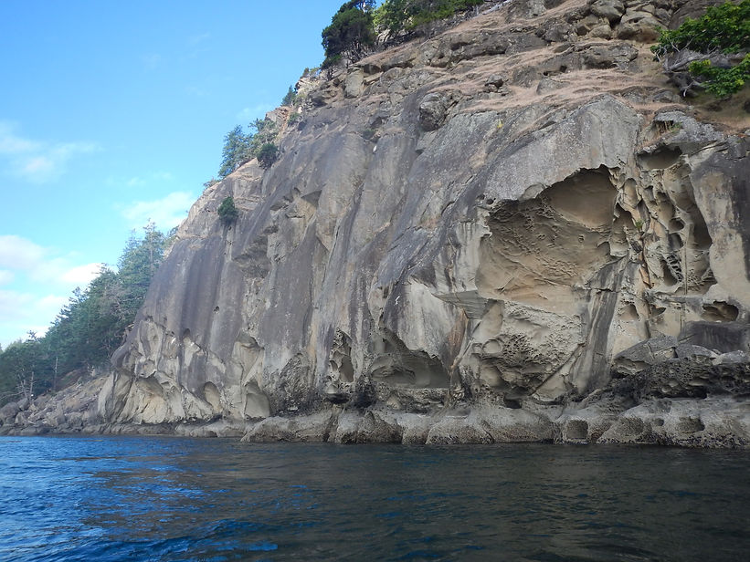
Nature’s sandstone sculpture, Saturna Island
Our route to D’Arcy Island took us past Turn Point, on Stuart Island in the U.S., which is where ships make a sharp turn as they head into Haro Strait. I didn’t want to cut too close to the point, into the shipping lane, but I needn’t have worried. The current helped swing us over to Moresby Island, in Canadian waters. When traveling in these waters in a kayak you learn to use the currents. This may mean getting up before dawn but if you want to get somewhere, you are much better off. We had begun easing into the natural cycle of things, the ebb and flow. As we were drawn up to this higher order our petty concerns were left behind. The moon rules!
These surging currents are key to the amazing life in these waters. Upwelling waters propel diatoms upward, which feed copepods and other plankters, which are gobbled up by other creatures, on up the marine food chain to salmon, which are feasted on by the Southern Resident Orcas, and by seals, which provide meat for the transient Biggs killer whales. And, of course, where the saltwater mixes with the muddy Fraser water, great, prolific things happen. All this is at risk.
South of Rum Island, which has a fine little campsite, there is an island with no trees that is home to the greatest concentration of pelagic and double-crested cormorants on Canada’s west coast. Evan and I call it simply Bird Island. Its real name is Mandarte. Unfortunately, the seabird population here mirrors the situation throughout the west coast. They are in serious decline. In 1983 there were 1100 Double-Crested Cormorant nests on the island. In 2000 there were only 215. In a 2001 study, reasons presented were lack of fish, predation by eagles, crows and seagulls, and boaters, which can flush out the birds and expose chicks and eggs to predation.[1] The island belongs to the Tseycum and Tswaout Bands, which allow wildlife research. There are four small cabins just for bird researchers, who have been studying resident song sparrow populations and sea birds for 40 years. Researchers have banded and tracked every song sparrow that lives on the island during that time and there are claims that this subgroup has been studied longer and more intensively than any vertebrate on earth (other than humans). We skirted the island this time because it is nesting season.
[1] (Double-Crested and Pelagic Cormorant Inventory in the Strait of Georgia in 2000, Trudy A. Chatwin, Ministry of Environment, Lands and Parks, Monica H. Mather, Ecological Consultant, Tanya Giesbrecht, May 2001)
Our final stop before reaching Victoria was D’Arcy Island. It is a favorite campsite but with a grim past. This is part of unseeded territory taken from Coast Salish First Nations. They would have used this island for summer fishing camps.
During the late 1800s and early 1900s it was a leper colony for Chinese immigrants. There was no contact with regular society except for a shipment of food and supplies that arrived once every three months. Today all that is left of that is a caretaker’s ruin covered in graffiti and a couple of overgrown foundations. This is a serene and beautiful island. The deer are quite skittish and run away almost before you see them. (although they eat much of the undergrowth and probably are responsible for the dearth of new arbutus trees. No wolves). Even the raccoons are wary. One immediately hauled itself up a big Douglas Fir when it saw me: the good kind of raccoon. That night some flickers squawked overhead, and some oystercatchers squealed down at the beach. Both species have long beaks that they use to peck and pry into places and suck out food. Both have beautiful plumage, are busy bodies and make a racket. Admirable birds. Evan noticed a hole in a stump where two flicker chicks were nested. You could just see two small heads with beaks sticking out. Mom or dad would perch beside the hole with open beak. Then youngster and adult would lock beaks and the two would vibrate back and forth. Vibration, regurgitation. The movement suggested the jack-hammer-like motion the young birds will learn to excavate tree bark and pry out insects. There were mounds of otter scat nearby, emitting a sweet fishy odor. It’s not a bad smell. The next day I watched a large otter rub itself on a log. It seemed to be pushing in one direction only, from front to back, smoothing down its guard hairs over its underfur. Was this to protect itself against cold and to provide buoyancy? Then it pranced over the rocks and into the water. It seemed confident and at ease. And why not? It came up with a small fish on its very first dive. Otters have very high metabolism and need to eat at least 15% of their bodyweight every day. There must be plenty of prey for them just offshore. Life at this island is thriving. The arbutus, oak and Douglas Fir trees are mature and healthy. The little white flowers on the salal underbrush provide nectar for a surprising number of bees. After a hundred years the dark past has been overtaken by vibrant growth. This park was set up in collaboration with Coast Salish First Nations and they have the right to pursue traditional activities on the island, including hunting deer. Perhaps this is one small, but important step on the path to reconciliation.
This is a perilous time. On this gorgeous island I got to thinking about the leader of the most powerful country in the world: one who is morally and intellectually retarded. There is a dark force coming out of his administration of fossil men, climate deniers and sycophants. The IPCC says we have 10 to 12 years to get GHG emissions way down and stop species extinctions. Global emissions are still rising. Overfishing is rampant. Only an advanced industrial nation can provide leadership on the most important crisis ever faced by humankind. I had thought that Canada might be that country, but its overly modest climate program has been mired down by wild and angry men in several provinces.
Then I thought about Greta Thunberg. She is 16, began protesting about the climate crisis in front of the Swedish parliament once a week last year, is articulate, and sparked student protests around the globe. I thought of Alexandria Ocasio-Cortez, 29, the youngest person to ever serve in the U.S. Congress. She submitted the Green New Deal to Congress and scares the hell out of the old Republican guard because she is so bright and fearless. There are lots of authors who have written on climate issues. Two who have influenced me are Elizabeth Kolbert and the super smart Naomi Klein. Definitely, more women need to be in positions of influence and power. The same applies to Indigenous people, whose ancestors knew how to live harmoniously in the natural world. We all need to learn from this precious knowledge if we are to survive.
As I sit here on this beautiful island healed by nature and time I have a measure of hope. Tomorrow we will get up early and follow the ebbing current back home to Victoria. I am not so ashamed of it anymore. There are new bicycle lanes and finally a sewage plant with tertiary treatment is being built. Can a local or global community call itself civilized if it can’t properly dispose of its own waste?
It is my dream that more and more people will find joy in being born on this blue orb and rise up and fight for it. Listen to the children. You can’t love them and this planet too much.

d'Arcy Island
Entered January 1, 2022
My province of British Columbia in 2021:
The COVID-19 pandemic raged for another year.
During the summer a heat dome caused the temperature at Lytton to reach a Canadian record of 49.6 C. The next day it burned to the ground. Over 600 excess deaths due to the heat were reported throughout the province. Smoke spread over huge expanses of the land and forests burned. Last month an atmospheric river caused record rainfall and flooding in major areas. All the highways and railways that connect B.C. to the rest of Canada were ruptured by raging water and landslides. Gas lines were shut down. Homes were flooded. A quarter of BC’s agricultural land was under water and an excess of 650,000 farm animals perished. Last week brought 42 record low temperatures. In Prince George on December 26, it was -40.7 C. In some areas temperatures swung 80 degrees within 6 months. This extreme variability is unprecedented, but with the climate crisis we are going to have to get used to it.
Meanwhile, the Trans Mountain Pipeline expansion is continuing. Capacity from the Tar Sands will be tripled. Despite Indigenous protests the pipeline for fracked natural gas to Kitimat is also still under construction. Oil and gas companies are predicting a really good year. Prices are up. Their industry had the largest number of participants at the recent COP26, last chance environmental get together. Gas and diesel powered, four-wheel drive pickup trucks continue to lead vehicle sales by a large margin. Canada has the most inefficient vehicle fleet on the planet as people continue voting with their wallets. In the U.S., President Joe Biden has approved thousands of new oil and gas leases in the Gulf of Mexico. Republicans continue to deny the climate crisis and, indeed, reality itself. China and India have refused to agree to phase out their use of coal.
This year I read of a philosopher and historian who said that it is no longer good enough to just comment on the climate crisis, you have to do something about it. Having come across Greenwave polyculture farming a few years ago I have recently been trying to start a regenerative sea farm, growing seaweed together with shellfish on Pender Island. We now have partners and have conversed with First Nations, local residents, the Islands Trust and various members of the shellfish and seaweed communities. We may, or may not, get permit approvals from the province, Fisheries and Ocean Canada, Transport Canada, and Tsawout First Nation. We are trying.
Recently I came across a study that concluded bottom trawling and dredging world-wide causes more CO2 pollution than all the world’s airlines. The damage to ruptured seabeds causes carbon in the soil, the largest store on the planet, to be released. Dredging is how most scallops and other shellfish are taken. This astounded me. All the more reason, as Jacques Cousteau pointed out, to stop plundering the ocean and begin growing and harvesting our food in it. Life on this precious planet is threatened. Yes, we are all part of the problem. But we can be part of the solution too. This year whales have increased in numbers off our coast, there was a big growth of bull kelp and the cormorants have returned to the cliffs on nearby Trial Island after a two-year absence. We must have hope.

Cormorants returning to Trial Island
